


Taking Flight
Individuals across outdoor service industries such as oil and gas, mining, construction, landfills, etc. agree that drones are the future for more reasons than one.
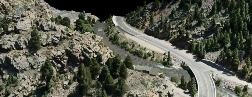
Garden of the Gods Highway.
The commercial UAV or Unmanned Aerial Vehicle (drones) market is growing exponentially every year due to the benefits these systems provide to outdoor service industries. The Federal Aviation Administration (FAA) forecasts that the number of commercial UAVs in the United States will grow from 42,000 aircraft in 2016 to an upside of as many as 1.6 million aircraft by 2021. Between conservative and upside estimates, that is three to forty times the growth rate of the hobbyist market. So why is this market growing so rapidly?
The commercial UAV market is growing rapidly in outdoor service industries due to the benefits achieved with unmanned aircraft. Some benefits include safety, project efficiencies, and new types of deliverables. “Outdoor service industries” include any type of industry for which services are rendered or received in the outdoors. For this article, we will apply these benefits to land surveying, specifically for the transportation, oil and gas, and construction industries.
Safety
An increase in safety concerns is inevitable when operating in the field, as opposed to the office. These industries, all have some aspect of working outside of an office. Concerns may be everything from moving traffic on a highway to a slope with a dangerously steep grade.
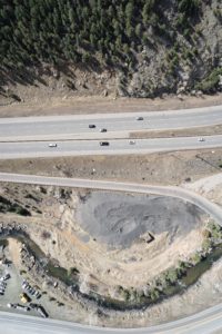
Aerial shot of I-70.
One example of mitigating safety risk is using UAVs for surveying on roadways and highways. Traditional land surveying involves working in roadways to collect geospatial data which will then be used for designing or constructing a road improvement or replacement. Although land surveying companies take proper precautions with traffic cones, flashing lights, and flaggers (to flag and direct traffic), accidents still happen.
UAVs allow land surveyors to stay out of the roads while still collecting the geospatial data needed to complete the project. Some tasks remain for which UAVs are not the correct tool, and conventional survey methods will be used. But when the amount of work done from the roadway with a person is significantly reduced, so is the probability of accidents occurring.
Efficiency
Another benefit to using UAVs on projects is the unparalleled efficiencies that can be gained. UAVs are able to capture significantly more data in a fraction of the time. Why is more data better? For oil and gas companies, often the final location of a well is not the original planned location. These changes may occur for a multitude of reasons such as an eagle’s nest that was not originally discovered, a new housing development that the well pad would encroach upon, or a possible geohazard that would put the well-pad at risk. When these changes occur, the new area must be surveyed, increasing project costs and extending timelines. 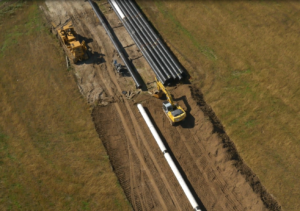
Instead of surveying only the initial well-pad area, UAVs can quickly and easily collect a much larger area of land. Then, if changes occur and the well-pad needs to be relocated, the data on the surrounding land has already been collected. This helps to minimize return trips to the field, lowering costs and remaining on the scheduled timeline for the project.
Deliverables
Finally, there is the benefit of being able to provide new types of deliverables. Traditionally, outdoor service organizations have worked in a two-dimensional terrestrial environment. Companies typically plan and execute their projects using paper and electronic drawings and design plans. Much like we ask what we ever did without cell phones before them, so are outdoor service organizations that have embraced using deliverables derived from UAVs.
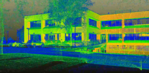
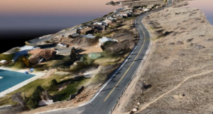
3D LiDAR scan.
Instead of observing a project from paper drawings at ground-level, project progression can be tracked in three-dimensional point clouds to see if any aspect of the project is off, within millimeter accuracy. Instead of describing a vision for a new highway interchange, it can be illustrated with three-dimensional visualizations and aerial videography. Instead of planning a housing development from outdated imagery and basic topographic CAD (computer aided drafting) drawings, plans can be developed based off actual up-to-date aerial imagery combined with broad scale three-dimensional elevation models derived from point clouds.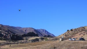
With the use of UAVs, companies have the opportunity to look at projects different than ever before. Outdoor service organizations can utilize enhanced planning methods at the front-end of projects, consume more data during the execution of those projects, and more accurately analyze the results of the project with UAVs. Projects can be planned and executed safer, more efficiently, and geospatial data is delivered in new and innovative ways. The markets for commercial UAV services are taking off.
The Author: Keith Hulen is the Director of Business Development at Ascent Geomatics Solutions. He has worked with numerous clients in developing customized solutions related to UAV and LiDAR.
 Bio coming soon.
 Hold for Lisa McCool bio.
 Hold for Christie Petersen bio.
 Scott Bass manages all Colorado survey crews at Ascent. He began at Ascent in 2019, and has a variety of skills, including GPS and Conventional field survey locations, AutoCAD Drafting, Revit drafting, Bid Package Preparations, Directing Operations, Business Development, Project Budgeting, and Deed Research/Analysis.
 Hold for Matt Morris bio.

 Chief People Officer
 Ramsey joined the Ascent team in November of 2017 and is CFO, as well as overseeing the Accounting, Finance, IT and Operations functions of Ascent. Ramsey brings more than a decade of finance experience across multiple disciplines including budgeting, FP&A, M&A, controllership, pricing and contract negotiations and treasury management.
 Founder
 Chief Executive Officer
 Regulatory Manager
 Director of Innovation
 Chief Operating Officer
 Jerry has more than 30 years of technical and project management experience in the field of land surveying. As a retired Colorado Department of Transportation (CDOT) employee of 30 years, he brings his knowledge of CDOT procedure and techniques to the team. He is involved in the day to day process, procedures, and workflows of the infrastructure related projects, project phase and tasks, and verifying the delivery of survey data for the infrastructure projects. Primary functions include the QA/QC of daily and final survey deliverables, project management, researching Right of Way records, ensuring Federal, State, County, and Local requirements are met, and the signing and sealing of survey related documents for recording. Jerry has been a licensed Professional Land Surveyor in Colorado since 1994.
 Program Manager
 Bob has more than 40 years of experience in the surveying and mapping professions. He has worked in the capacity of owner, survey manager, office manager, and project manager for surveying, construction and engineering firms. As a Professional Land Surveyor, he has experience working on survey projects involving Primary control layout, construction, boundary, mining, oil-gas, topographic, and design. He has provided these services to a variety of clients including CDOT, Arapahoe County, Jefferson County, Clear Creek County, City and County of Denver, private engineering firms including CH2M Hill, Carter Burgess, J.F. Sato, Merrick & Co, Washington Group, Nolte Associate, and construction companies including Johnson Brothers Construction, Ames Construction Co., Sema Construction Co., KiewitWestern Construction, Kelly Construction and Lawrence Construction Co. Bob has been a Licensed Professional Land Surveyor since 1983, and holds an Associate Degree in Surveying from Red Rocks Community College.
 Productions Manager
 Engineering Manager
 GIS Manager
 Senior Field Coordinator/Crew Chief
 Colorado
 Data Processing Specialist
 Controller
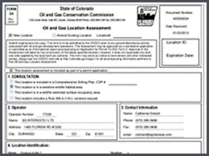 Upstream oil & gas operators have one simple goal: find and drill hydrocarbons. To do this, operators must navigate the regulatory gauntlet to receive their necessary permits. Without the proper expertise and experience, operators can lose valuable time and possibly even lose the location itself to another operator.
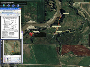 Extended Text for Popup: The ability to manage all your assets is critical to running an efficient organization. Having the ability to view floodplain, wildlife and/or utility lines can help operators better plan their sites for Surface Use Agreements (SUA).
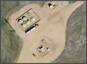 Viewing up-to-date aerial imagery can help save companies thousands of dollars by avoiding previously unforeseen challenges at the site location.
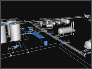 Most oil & gas operators will create as-built drawings for their well pads, pipelines, facilities and any other construction related projects. ASCENT has completed thousands of as-built surveys and drawings for our clients. Our extensive experience has taught us the most efficient and cost effective ways to create these as-built deliverables.
 When companies are looking to design, or modify a facility, there is no reason not to use LiDAR technology. LiDAR provides design-grade accuracy with 3D modeling to see how the facility will look after construction.
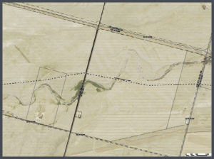 Pipeline projects can cost millions of dollars. Missing the project timelines can cost midstream operators even more money. That is why planning on the front-end of the project is so important.
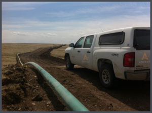 Longer pipeline corridors can take a significant amount of time to create topographic surveys with traditional methods. With aerial LiDAR, ASCENT can significantly reduce the time it takes to create these topographic surveys while providing a tremendous amount of useful data. This highly accurate pre-construction LiDAR data can then be married with highly accurate after-built LiDAR data to determine the precision of the planned and constructed pipeline.

