


Utilization of Blue Sky in Midstream Operations Webinar Transcription
Good afternoon, everyone. My name is Keith Hulen, Director of Business Development here at Ascent Geomatics Solutions. I want to thank you all for joining our webinar today. I am going to go through some quick introductions here and then we’ll go through our agenda for the day. It should be pretty short and sweet today, we’re just going to be covering the topic of how to make some of the pipeline projects a little more efficient. So, with that I’m going to go ahead and start moving through some quick introductions. Of course, I already introduced myself Keith Hulen and then I’m joined by the esteemed and the very popular George Prien as our production manager and he’s worked for years and years using this equipment, so George, welcome.
Thank you very much. I’m proud to be a part of this webinar this afternoon, and excited to get going.
Alright, sounds good. Well, let’s dive into our agenda for today so we’re really going to make this pretty simple. We’re essentially, you know Ascent Geomatics Solutions, we’re a survey firm and so we have surveyed a lot of different types of projects in a lot of different industries. And so, we can speak to this from experience surveying without Blue Sky which we’re going to cover in the first half of this webinar – talking about what tools are used, what does that process look like, what challenges exist as a result, and then what are the negative business outcomes that occur as a result of using those tools in that process and having those challenges. So, we kind of start with current status quo and then we’ll move into what happens when you introduce Blue Sky into your environment. Now what are the tools you’re using. What does the process then look like? What benefits instead of challenges are you dealing with. And then what ultimately are the positive business outcomes that you’re going to get as a result. So that’s our agenda. And so we’ll start as I mentioned with current status quo. So what we’re going to talk about is how most of the companies, generally speaking, these are the sets of tools. These are the different processes they have, the challenges, and then the negative business outcomes. And so with that George you’re the subject matter expert here. So tell us about in most of the existing processes that survey companies are using what types of tools are they using.
Yeah Keith in today’s business and especially in survey and engineering we are typically using a myriad of software. We’re using AutoCAD to import points, we’re using Carlson and TBC products to process those points, and even excel and CSV files. Those files and good tools albeit don’t have the quality assurance and the quality control applications that other software packages have. So they have their place in the market but not used for survey validation and survey quality control.
So, these are the tools that the companies are using today, most of the survey firms today. So what you know, when you use a certain set of tools, that’s going to dictate a certain process, right? I mean you can try and tweak that process and make it as efficient as you possibly can but ultimately, you’re going to only be able to do so much. So what does that process look like, and by the way I’m sure this slide demonstrates that well, but maybe you can explain a little more detail.
I love your slide; it’s a lot of chaos, and that can definitely happen in your business process if you do not have a good quality assurance and survey validation process in place. Typically, and from a conventional point of view, we have survey crews that go out and those can be multiple crews, could be single crews and then what happens is as the data is being collected, it could be nightly, daily, weekly, depending on what your processes for importing that data into AutoCAD CSV spreadsheet TVC whatever the process that you’re using. What ends up happening is once that, you know, that product and that information gets downloaded to your office, somebody in the office actually goes through each record or each point to make sure it’s correct. If you don’t have a quality assurance or quality control plan in place, you can imagine what that can do. It’s a lot of time, a lot of effort, and manpower to do your quality control and your quality assurance. So, once we get into the office and it’s being processed, we can then now import that information into AutoCAD or a design based file, you know, give it to engineering for them to do their design and then so on and so forth. What ends up happening though, is if we are manually doing this process we cannot find errors down the road. If we’re relying on this information from a manual process there could be potential huge errors of impact to an engineering design. So, what that impact is obviously more cost, timeline impacts, and deadlines in time etc.
So, when you talk about time, you know, you mentioned that there is a lot of time that could be invested in that. Could you give me an example just when you’re looking at these at this amount of data, I mean how many different points should we be looking at here? How much time would you be spending going through an Excel spreadsheet?
Absolutely and it’s a great point. When you are, especially in midstream where we have a very lengthy pipeline projects and we are shooting welds you know pipe joints together there could be thousands of weld points right. And so, you can imagine looking through thousands of weld points and if your data is incorrect you may or may not know it because you were having to look through so many records. If you had something in place that was going to check it for you, an automated checker for instance, then you can pinpoint fields that may have not been populated fields, that may have been populated incorrectly, and et cetera et cetera. So, you can imagine going through thousands of records with your eyes on the screen looking through a lot of lines; that could be very tedious.
Okay. So just like the tools will dictate the process that process regardless how you want to tweak it you with the certain tools that you can only kind of tweak it so much right. And so just as we said that the tools would dictate the process the process is going to dictate some certain challenges as a result.
Right.
So what kinds of challenges are you going to have as a result of having that process?
A lot of manual tracking. So, am I looking at documents and trying to correlate field book information, manufacturer’s test report information, to get and validate heat numbers sizes? You have to look at other contactors information like pothole companies, surface locate companies, so you can imagine having all these different documents that all that information has to be compiled into one spreadsheet or one CSV so that information, when it gets imported into the AutoCAD file for the guys doing the actual design, engineers can do their jobs. So, you can imagine having all that documentation there’s bound to be some errors in your manual tracking process manual searching as well. If you’re having to go through and do control find in your CSV or spreadsheet it could take very long period of time. Look at your field book. Look at this this point number. Go back to your spreadsheet, go on find it in the information correctly. You can imagine having to do that for a lot of records, even thousands of records. You’re going to spend a lot of time doing that. Another thing that we typically could encounter, or have seen, is copying and pasting errors, copying information from another spreadsheet that needs to go into that spreadsheet. Maybe it’s a pipeline that we’re validating material. That information definitely needs to get into your spreadsheet. And if you’re copying one field incorrectly or maybe you scooted it over or you cut it incorrectly and you paste it in your spreadsheet, you’re going along your daily business and then find it, later on find out that there’s a problem with your data loading or your data tools or something wrong in the database that you’re actually delivering to the client. So those manual errors, copying and pasting errors, are crucial. And how do we how do we evaluate how do we have a quality control method over that. And overseeing that that’s a tedious process.
And so obviously being manual in nature it sounds like there a lot of human involvement in this process. I mean that’s generally where there’s more means that if a process is more in your nature and humans are involved in that manual then there’s just inherent errors that that are going to occur. Would you agree?
Absolutely.
And so you know as we talk about some of these challenges, ultimately we’ve got to look at what’s the impact to the business. And in this case obviously there could be some negative types of business outcomes with that type of process, those types of challenges, so maybe you could just elaborate a little bit more on what is the result then if you’re experiencing those challenges as a survey company.
Yeah you could inadvertently send data to a client that you may not have seen those errors and they could be on their side. Importing those into their systems their GIS system they have to do that for regulatory compliance. They may have found something and then they just send it back to you. And if you’re going back and forth in that manner you can obviously see that there’s an expanded scope there. The expanded time line is also impacted. If we can’t get that into the engineering or the engineers are finding errors. Obviously we’re going back and forth our manual quality control quality assurance can also take too much time we’re not going to be able to hit those deadlines, engineers won’t be able to hit their deadlines or they have to go and tell their client they can’t hit their deadlines because survey hasn’t hit their deadline. So it’s also that ripple effect.
And so I’m going to guess none of the operators you’ve worked with would appreciate having a longer time lines more cost and just the general expanded scope.
No, they’re always beating us up for extended scope and expanded timelines.
Fair enough. And so I threw this one in here just because you know when you have these things as a survey company you’re already going to find the situation of you know kind of looking at who do we blame and for any of those things why is the project scope expanded Why is the timeline expanded. Why are we having errors that is causing a ripple effect as you said to these other different groups. And that’s why I thought this would be a relevant image to show here because this is there is actually some truth to this and this is what we I guess try and avoid if possible right by using a different set of tools. Let’s talk about some of those tools. So in your experience you’ve worked with surveys firms, actually for survey firms that didn’t have any of this any of these tools we’re getting ready to talk about obviously some of what you just got done talking about is from personal experience right. I mean you’ve actually gone through that but you’ve also been now on the other side of it where you’ve used blue sky type of tools and now you’ve seen a different type of process and some inherent benefits that result from that process and now instead of negative we’re talking about positive business outcomes is that a fair statement?
Absolutely and I’ve been on both sides; engineering and surveying. So I understand the repercussions on the engineering side when that survey data is coming in late or it’s coming in incorrect. I’m the one that has to fix it right I’m the data manager I’m the one that has to fix that I’m responsible for it, or I’m the GIS analyst I’m responsible for that information and when it comes incorrect, I’ve got to kick it back or fix it myself. Do I spend the time fixing it myself or do I send it back to survey. You know those are the challenges that we see. So if we can work hand in hand and have these tools validate while we’re in the field into the office and have a very streamlined process it’s going to be a positive business outcome.
Great. Let’s start talking about some of these tools. So we’re talking about blue sky of course right. And there’s obviously a suite of solutions that blue sky offers. We’re going to talk about three in particular dash rev and lightning. So maybe you can just kind of give us a high level understanding of blue sky. For those of us the folks that are not familiar, I know I communicated with a few people that I sent this invitation out to that are really not that familiar with blue sky at all so maybe you could start with just kind of a high level blue sky and then high levels some of these and they will dig a little more detail on them.
Yeah absolutely. Blue Sky development company has been around for almost 20 years. They service approximately 90 percent of the oil and gas industry as far as alignment sheet generation data management and now data and asset service applications. So with the alignment sheet generation obviously we’re talking about survey data and integrating that into our process and workflows.
And just for the record because we are recording that you’re not a paid spokesperson for Blue Sky Is that correct.
No, I am not a spokesperson
But you are a big fan.
I am a big fan.
Because this really does provide big benefits to all types of midstream.
Yeah absolutely. We, at Ascent, have these tools in-house and we use them, and are continuing to use them regularly because they work for us. And the way our business is set up, we are more efficient because of these tools.
And one other clarifying point you said 90 percent of kind of oil and gas companies are using this, but what about water infrastructure pipelines, you know other types other than oil and gas, but still talking about pipeline does everything we’re getting ready to talk about still apply to all of that.
Absolutely anything that involves the plan and the profile; water lines, sewer lines, storm drainage lines, telecommunication, anything that’s linear that you have to have a plan view and a profile attached to it. You could use these tools.
Okay. Very good. So let’s dive into the presentation. And first we’ll start with dash. Tell me about dash, George.
Dash is an automated survey validation tool where we can not only from the field have our surveyors import information before and stage data before it even gets to the office. This is a huge advantage instead of the conventional method, of doing a conventional survey, processing that survey, sending it in to the office, and having them validate and manually check codes for correctness. So not only does it do that but it’s also a material validation tool that is compliant with regulatory documentation. You can attach it for any DOT material test reports send the reg documentation permits anything that you could think of that you would need to build a pipetally or as-built information or plats or Geotech information you can link documents into your data.
Great. So I think we have a little more here. So this is just a little more detail around Dash.
Yeah, another thing or another great tool that dash uses or its capability is writing data to your spatial database I can bring in my points and have them be validated and that’s great. But where does it go from there? It gets automatically pushed to your spatial database so that it’s automatically built into the client schema for pods deliverable – pods deliverable is that Geo database where operators are using to manage their assets.
Great and I think now we can kind of switch over and let’s talk a little bit about Rev.
Yeah and so Rev is basically that database that is triggering from point information from the spatial database. So if you think about it in terms of a workflow, Rev is your brainchild and it’s also comparing data is being pushed into spatial database and to the Rev database. So, you can not only do GIS applications, AutoCAD. You’re sharing your data and it’s being collaborated through all your groups. So, if you have a GIS group, an AutoCAD group or mapping groups those groups can all share data and work together instead of separately. Typically, in different environments without the BSD tools. You are doing things maybe at the same time or maybe not. GIS has deliverables for pods and AutoCAD or mapping groups have deliverables in alignment regeneration. If those two datasets don’t match your data is going to not be good. And the operator will see it and it will get kicked back to you.
And so in layman’s terms here for people like me this is a one stop shop meaning that instead of having disparate tools and systems and all that stuff where data resides in multiple different areas, we’re talking about all this data residing in one area so that everything is consistent across the board and you’re going to eventually create alignment sheets, or whatever that might be.
Correct. We don’t have multiple CSV files or multiple data files that mapping group is working with. We have one data set and that data is being pushed into your database and it’s being pulled to create your alignment sheets and deliver the client schema.
Okay great. And then I guess that takes us to lightning as the kind of third tool we’re talking about here. So tell me about lightning.
Yeah. Lightning is our fast efficient alignment sheet generation tool. Once we get our data from the field and our material has been validated. We can then push that information to the brain childm the spatial database once that data is in there. All we now have to do is pull it through lightning which is a GIS based application. It uses ARC info ARC map. All those ESRI tools that you have at your capabilities or your fingers to produce very high level maps great looking maps exhibits, permits, a lot of different applications. This is more of a GIS based tool. We also have the AutoCAD based tool where we can still do the same thing. It’s just in an AutoCAD version.
And so are you going to see a difference in the deliverables. I mean when you look at the old process as we talked about earlier in the webinar versus using lightning as an example are you going to see a difference in the actual deliverables that the client’s going to get.
Yeah you will just the quality and the GIS application is much higher. You’ve got higher resolution imagery you’ve got better automated tools easement bands different bands material bands are easier to populate and automate your plan view is more automated. Text is clear cleaner AutoCAD is just a little bit different. A little bit more manual work a lot of drafting a lot of editing that kind of thing. So although they are very similar. One application is a lot faster in this mission than the other.
So OK. And so these are the tools. So just like we were talking earlier about existing tools now we’re talking about these new tools. Now what type of a process do these types of tools create.
Yeah. What you can see here on the screen is basically this streamline process using the tools from field data and you see that here on the left side. And that’s our survey data from the field coming into the office automated through dash that’s being pushed through with the brain child there in Rev. And from there we can pull that information or that we can push that information to your spatial database and from there we can pull that out into AutoCAD and we can do reporting from there. We can generate reports for the operator from there we can push the pod Geo database scheme from our database directly into the client geodatabase very easily.
And so this is going to create some inherent benefit I guess is where you’re going with this, right? The challenges that exist in the older process. Now we’re going to have benefits that exist here. So what do those look like?
One being the auto validation right. We start with dash. You can now instead of manually looking through those thousands of records you can now pinpoint exactly what the client schema is. So if you have codes for example that have multiple required fields you can do a very quick validation on that specific thing. If it’s required flag it if some if there’s no data in that field flag it. If it’s an alpha vs number field flag if it’s not populated flag it. If the data doesn’t match my MTR report flag it. So there is that linking ability especially when we talked about that earlier we can link and document especially like very important stuff like manufacture test reports. Make sure heat numbers are correct. We can link those documents now to dash and make sure that our heat numbers from the survey data is matching our reports or MTR reports and that is very important when operators look at survey data. One of the first things they look at do the heat numbers match up with our documentation because if that doesn’t happen. You can’t you can’t install it it’s a big deal. Some operators require one hundred percent. Hundred percent validation. That is huge. And that is a lot a lot of extra effort. And if you can’t provide that documentation or backup of what you did you are going to have problems. Right. The reporting if I can report that to a designer to a surveyor. Hey by the way this is what we missed. They can go back and fix it or find out what happened. All that data being stored in one location it’s in one database. So it’s easy to report. Everybody has information everybody sharing everybody’s collaborating. We don’t have the two different data sets and you’re doing something and I’m doing something and we’re not talking. Right. That happens a lot we’re too busy. We’re not talking we’re doing two different things. We’re going two different directions. Now you don’t have to worry about that. It’s all collaborated it’s all being shared. Everybody has their information.
And then not being able to is not just having that duplication of the efforts right.
So yeah that’s what I was talking about. You might be doing one task and I might be doing a different task and if I don’t have the tools we are duplicating efforts or changing things at different times.
Is it possible you could even be duplicating those efforts using different data which might even be a different problem.
Absolutely.
So this all makes sense and I understand these benefits and hopefully everybody on the webinar understands. I want to ask very candidly so what? So OK these are great auto validation is great reporting is great. What ultimately what does that mean to an operator. Why would they care that a survey firm like us is using a tool like this what is this going to do for them?
Yeah obviously when you just look straight up at it, the common themes come out right. Overall costs. We can offer the baseline, we can do it for less. We can do it quicker. We’re going to have less errors. So our high quality of data or deliverables are going to be with less errors. We are also going to be doing it faster. Right that’s just a general high-level stuff. Right. But also what are we gaining, we’re gaining a really good piece of information that can be shared that we can share with our operators that we can share with engineering. We have online tools right. Associated with these tools we can collaborate. They can go on and do real time sharing. We can have you log on to our website and you can look at the data. Oh they generate this amount of data and think about it too. If you’re a surveyor and you’re in the field and you can validate your data before it gets to the office you’re miles ahead. So there’s a huge cost benefit there, and savings.
Alright, so I got to ask, this question. So quality goes up, the efficiency in the project goes up, the speed at which you are able to execute on the project is better the costs are lower. What’s the catch?
The catch to the client? They get a high-quality product.
That’s not a catch, alright I’ll let you off the hook. It just sounds like it sounds like a pretty good deal.
We don’t charge extra for having these tools. Right. This is a benefit to the client and to their clients. You know if we are sub to a contractor This is a benefit to them. Right. This is the way for us to really set ourselves apart and say hey we are at the top level we are here and doing and producing high level deliverables
So at this point I want to just throw out to anybody that on this webinars that if you look on the right hand side you probably see a box there where you can ask any questions at this point would be a great time if you’d like to submit some questions we’ll be taking questions at the end. And what we’ll do is just a quick recap and then maybe some recommendation and then we’ll open it up for any questions that you may have. So again on the right hand side the box you should have a little triangle there that you can open up and submit your questions so in review here, George, we’re talking about ultimately a tool that takes away that human manual effort. Right. And essentially automates it the way that technology in computers and all this is supposed to do right. And so what we’re doing is getting rid of all these different tools disparate tools that folks are using and combining it into one tool that’s all working off of the same database it’s all working off of the same data and then providing some huge efficiencies right is that kind of saying the difference between the tools?
Correct.
And the process used. The difference is we’re talking about is going from obviously a kind of somewhat disjointed or convoluted process where there’s a lot of moving parts. There’s a lot of time invested in actually scrolling through thousands of lines of Excel and now we’re talking about going into a process that is automated. That is a lot smoother and all works together. I mean that’s the whole point of using this different suite of solutions underneath blue sky right, is that they all work together well in the sandbox.
Absolutely.
Anything else you’d want add to that.
No I think you hit all the key points in the collaboration the automated tools the working together everything’s connected. There isn’t that duplicity. Know that one group is working and the other group is working. And they may have different deadlines right and they they’re working now together those groups are now together they’re using the same data set.
And so if we change the tools we can, not just slightly change, but fundamentally change our process which then leads to taking these challenges that survey firms are used to using and really kind of turning in the benefits. Now right now we don’t have this manual process, it’s automated. Now we don’t have humans that have to you know look at the screen at 2:00 a.m. through lines and lines of different codes. Now you’ve got a computer doing that right which should be able to do a better job of that and you’re not taking the human element out of this completely right. I mean we’re still we’re still going to have a human involved, but we’re just trying to take out all of those small little small little details that hopefully computers can pick up on. And ultimately then we turn what would be possible negative business outcomes into positive business outcomes. We don’t delay the project. We speed up the project. We don’t increase in the scope which increases the cost we hopefully decrease the scope you know and make the cost what they should be what they’re estimated at and if not possibly even a little bit lower because we’re more efficient. So if that’s all accurate anything else is going to add to that.
No I think you hit it on the head.
So ultimately if you don’t change the tools you’re not going to have an impact on the business outcomes. I mean the stuff in between is really just a result of the tools that you’re actually using right change the tools. You’re going to get a different outcome.
Correct.
Great. So any recommendations that you would have just for any of the folks that are out there and kind of jump into some questions.
Recommendations? Find a way to provide a efficient quality control or insurance plan for your business.
Got it, well at this point I’d like to open it up to any questions that are out there right now we’ve had a just a couple of questions that have kind of trickled in here. Let me pull these up and I will go ahead and start with. OK. So I’ve got a question here. I think you actually mentioned something about this earlier how much more do you charge your clients because you use this new suite of software.
Yeah like I said earlier we don’t charge our clients extra to run the software. And this is a benefit to the client and to as a subcontractor to their clients. So we believe that delivering high quality deliverables from a production standpoint is one of our main goals.
So the hope here is by investing which Ascent has obviously done by investing in this type of technology it’s our hope that we’ll continue to get repeat business and then obviously our clients will talk to other people. Say you’ve got to use these guys that use tools and you know Blue Sky is just one solution obviously we use internally here to make these products more efficient but hey a team that uses that so that’s kind of the idea behind how we recoup that investment for what we spend on these.
Absolutely and we do currently get repeat business because of it.
Another question here. Are there any operators that are using the blue sky products.
That’s a great question and yes. And there are a lot of operators that use the suite of blue sky tools. It is very embarrassing when an operator comes back to you and gives you a report with all these highlighted fields with data missing from a dash report that is very embarrassing that is something you don’t want.
Yeah I can imagine that I can imagine that would be embarrassing. So good there and then I just have it looks like we just have one other question here. How many survey firms would you estimate are actually using these products. Now obviously that is a hard question to answer. I’m think there’s really no way to know. But I don’t know what your best guess on that.
From my experience there are a lot of survey firms that use some of these. One of them or a combination of them. All I know is based on my experience and here at Ascent we use all of these tools. We are in spatial, have GIS and we have a host of tools that do quick alignment generation.
So while we still have this recommendation up I guess I have to throw in one last one which is if you have an opportunity that you have a midstream project coming up, give us a shot and let us show you how these tools can actually benefit your project and let us put our money where our mouth is. That sounds good. Well thanks everybody. We really appreciate the time. And George I want to thank you for the experience and expertise that you provide. I know you use these solutions and you believe in them I know very strongly. And we use them here internally at Ascent. I can speak from experience. I know we’ve had really good success with them so if you have any questions please feel free to reach out. My information is here on the last slide and otherwise this concludes the webinar and we thank everybody for joining. And George thanks again.
Thank you for having me.
 Bio coming soon.
 Hold for Lisa McCool bio.
 Hold for Christie Petersen bio.
 Scott Bass manages all Colorado survey crews at Ascent. He began at Ascent in 2019, and has a variety of skills, including GPS and Conventional field survey locations, AutoCAD Drafting, Revit drafting, Bid Package Preparations, Directing Operations, Business Development, Project Budgeting, and Deed Research/Analysis.
 Hold for Matt Morris bio.

 Chief People Officer
 Ramsey joined the Ascent team in November of 2017 and is CFO, as well as overseeing the Accounting, Finance, IT and Operations functions of Ascent. Ramsey brings more than a decade of finance experience across multiple disciplines including budgeting, FP&A, M&A, controllership, pricing and contract negotiations and treasury management.
 Founder
 Chief Executive Officer
 Regulatory Manager
 Director of Innovation
 Chief Operating Officer
 Jerry has more than 30 years of technical and project management experience in the field of land surveying. As a retired Colorado Department of Transportation (CDOT) employee of 30 years, he brings his knowledge of CDOT procedure and techniques to the team. He is involved in the day to day process, procedures, and workflows of the infrastructure related projects, project phase and tasks, and verifying the delivery of survey data for the infrastructure projects. Primary functions include the QA/QC of daily and final survey deliverables, project management, researching Right of Way records, ensuring Federal, State, County, and Local requirements are met, and the signing and sealing of survey related documents for recording. Jerry has been a licensed Professional Land Surveyor in Colorado since 1994.
 Program Manager
 Bob has more than 40 years of experience in the surveying and mapping professions. He has worked in the capacity of owner, survey manager, office manager, and project manager for surveying, construction and engineering firms. As a Professional Land Surveyor, he has experience working on survey projects involving Primary control layout, construction, boundary, mining, oil-gas, topographic, and design. He has provided these services to a variety of clients including CDOT, Arapahoe County, Jefferson County, Clear Creek County, City and County of Denver, private engineering firms including CH2M Hill, Carter Burgess, J.F. Sato, Merrick & Co, Washington Group, Nolte Associate, and construction companies including Johnson Brothers Construction, Ames Construction Co., Sema Construction Co., KiewitWestern Construction, Kelly Construction and Lawrence Construction Co. Bob has been a Licensed Professional Land Surveyor since 1983, and holds an Associate Degree in Surveying from Red Rocks Community College.
 Productions Manager
 Engineering Manager
 GIS Manager
 Senior Field Coordinator/Crew Chief
 Colorado
 Data Processing Specialist
 Controller
 Upstream oil & gas operators have one simple goal: find and drill hydrocarbons. To do this, operators must navigate the regulatory gauntlet to receive their necessary permits. Without the proper expertise and experience, operators can lose valuable time and possibly even lose the location itself to another operator.
 Extended Text for Popup: The ability to manage all your assets is critical to running an efficient organization. Having the ability to view floodplain, wildlife and/or utility lines can help operators better plan their sites for Surface Use Agreements (SUA).
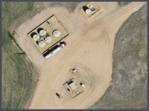 Viewing up-to-date aerial imagery can help save companies thousands of dollars by avoiding previously unforeseen challenges at the site location.
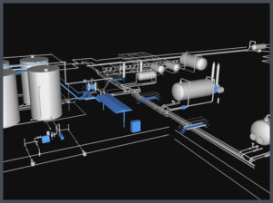 Most oil & gas operators will create as-built drawings for their well pads, pipelines, facilities and any other construction related projects. ASCENT has completed thousands of as-built surveys and drawings for our clients. Our extensive experience has taught us the most efficient and cost effective ways to create these as-built deliverables.
 When companies are looking to design, or modify a facility, there is no reason not to use LiDAR technology. LiDAR provides design-grade accuracy with 3D modeling to see how the facility will look after construction.
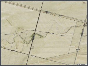 Pipeline projects can cost millions of dollars. Missing the project timelines can cost midstream operators even more money. That is why planning on the front-end of the project is so important.
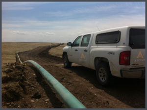 Longer pipeline corridors can take a significant amount of time to create topographic surveys with traditional methods. With aerial LiDAR, ASCENT can significantly reduce the time it takes to create these topographic surveys while providing a tremendous amount of useful data. This highly accurate pre-construction LiDAR data can then be married with highly accurate after-built LiDAR data to determine the precision of the planned and constructed pipeline.

